Monday, November 29, 2010

Snake Island


The waves were a bit rough on the windward side of the island, so I paddled around to the back side and a small cove where the water was still and landing was easy. Snake Island is a rather large island in the midst of the many islands in the area.


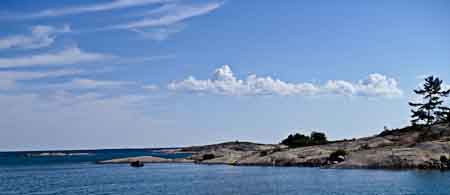
Crossing the channel from the main land to Snake Island
I walked around the cove noticing the fire rings on the rocks and away from the tree areas. Some great camping spots with mossy ground. It looked inviting for setting up a tent and comfortable  for sleeping. The top of the island had a wonderful view of the bay.


The lee side of Snake Island

I took a swim and enjoyed the windless north side on the hot rocks. Just like a pool, the slabs of stone were large and warm after a swim. Looking at the map, I discovered the island was called Snake Island, so I thought I would look around a bit for snakes.
There were juniper trees and low-lying bushes, grassy areas and large rocky areas.  Fortunately I didn't find any snakes, but there must have been a good reason to name this island after them. Since this was the Killarney area,  St Patrick came to mind and I figured he cleaned out this area also. 


Mike and Anna crossing Collins Inlet
 I watched two other kayakers cross and land on the island, hike up the hill to the small peak where I was standing.
Looking South towards Killarney
After they saw the cove where I had landed they moved their gear to the lee side and started to set up camp. I would think that after exerting so much energy paddling that I would be hungry and ready for an evening meal. Food didn't cross my mind until Mike offered me an apple.  I stuck it away for later. That evening as I did finally camp, I found a simple thing like an apple was amazing. That was a whole meal for me that night. 


I loaded up again and headed out for Solomon Islands farther east. I was used to afternoon and evening wind dying down and expected the waters would be still in the coves behind the islands. I took some more photos of the island, said good by to Mike and Anna and headed east along the coast. I was looking forward to evening golden light and reflections of stone faces. It was about 7:00 pm and it didn't get dark till about 9:30. Plenty of time to do photograph and still set camp.
I paddled past some small rock out cropings and headed northeast along the coast still sheltered by the island.


I floated past some great campsites with more campers on other islands.  It wasn't overly isolated nor was it crowded. It was good to see some people in the area yet not too close.


The only noise were the waves and wind. I could see Solomon Island in the distant and set course for the pine tops.


Continued....  Solomon Islands?

Sunday, November 21, 2010

Cerulean Waters of Killarney

 I was in Wolf Country, a billboard caught my eye and told me so. I would love to see a wolf in the timbers. I drove north out of Britt and towards Killarney, a two hour drive.  I turned onto Hwy 69,  the only road to Killarney.  I wanted to see the landscape, but the silhouette of pine trees at dusk was all I could catch of the area. Arriving in Killarney after dark I knew there were camp grounds around there some where, but I was dog tired and pulled into a pay parking lot behind a church to sleep in the van.
The evening was still hot at 11:00pm, as I tried to figure out how to set the tent up in the van for the mosquito net. I stretched the netting between the clothes hangers in the van, crawled in, zipped the net shut and slept to  the drone of bugs. A great source of white noise.
Sounds miserable, but I slept well and it wasn't that bad, The bugs didn't arrive until after dark .


The next morning I walked about Killarney to find a place for breakfast. I wanted to get acquainted with the area and the people of this little town.There were no traffic lights.  There was one grocery / dry goods store under renovations, three marina's, three or four restaurant / bars, A fishing business that ships fish out as well as offers fish and chips on the dock, It fills up on the weekends with travelers and boaters.

Killarney Church on Main St

I met John, a sailboat owner who was repairing his boat after a winter in drydock and launching that day. He was looking for a buyer for his sailboat and an adventurous type to join him on a trimaran sailboat that he would sail from Florida to Cuba to Cancun Mexico. Actually it was his wife looking for some other person to join him in his trip. He was going to go alone. I considered it for about two seconds and thought about the last time I was out on the ocean. a captain kept asking me "What ya looking for down there? I was leaning over the edge all day LONG.


I drove out to the view the light house on the edge of town looking for a launching place.


Area around the light house


Light house view from land


Parking is a premium in Killarney. The state park wanted $14/ day to leave your car overnight,and there weren't too many access points to the bay close by. A Marina owner, Dutch allowed me to park on his property and launch from the public park next door. Dutch also had some great bear stories. One mother had crossed the channel with her two cubs in tow. The smallest lagged behind and started to cry out. With out missing a beat the mom and the other cub circled around and got behind the lagger and stuck with him till they reached the other side. Another time a cub walked into Dutched marina looking hungry, Dutch put some dog food down, and the cub ate it, and left only to return and leave some scat on the floor. Of course he wasn't welcome anymore.


Across the channel from Killarney


Across the small bay from the lighthouse


I launched from the mid town area about 2:00 pm. There was still about 8 hours of light left. I paddled through the channel that leads out into the northern part of Georgian Bay. I followed the coast towards the light house.

View of the light house from the water, turning the point

I paddled north following the coast through some of the most beautiful water I have ever had the chance to paddle in. and on up to another channel crossing to the islands.


From the wind protected West side of the main land I paddled the coast and towards the channel crossing the narrowest point of the inlet. The crossing was large waves and very windy. I like paddling into the wind and waves, water crashing over the pointy bow of the boat. I was not used to paddling with the waves coming at me from the side lifting me up on the peak and dropping me into the trough. I was not experienced in these conditions, a loaded boat made for a more stable boat. I caught on but was still on alert.  My original course was for Solomon Island, but with the wind and waves I headed towards the lee side of the first island I came too.

Continued  Snake Island

Wednesday, November 10, 2010

The Storm

continued from Telluris Vultus II

A light breeze had risen as I paddled on the edge of the Canadian Shield of granite. To my right was open water and the left were the smooth rocky islands. I left Norgate Inlet and moved south towards Nasicoot River. Passing tree covered rocky shores.


I spotted a cottage in the trees on the edge of the open water and thought of storms that may have cast waves large enough to hit the home. The trees all leaned towards the east. Winds could be a constant at certain times of the year. Next to the home there stood a large rock carin as I called it but the Canadians called them Inuksuk. Markers on the trail.


Three canoes emerged from behind and island moving in the same direction I was headed. The water in front of me started to get choppy as I made my way towards the canoes. I was hoping to get a clear idea of my exact location, as there were no sign posts or named areas. I paddled over very shallow water that would rise and fall on the flat rocky area I was crossing. The rough water would lift me up and drop me to the rocks and I hit the rock shelf a few times.  I was a bit puzzled because there was only blue sky and a slight wind in my face. Turning around I saw a white sheet of cloud surrounded by a dark grey sky that engulf the island I had just passed. It was barely visible as the rain started churning towards me.
This squall was moving fast, over taking me and I decided to get to land. There was some thunder, but I didn't turn around to look for lightening. I was the high point on the water and I didn't want to get fried.  I paddled towards the canoers who had landed and were now taking cover in the low trees. I paddled after them and landed.


I thought I may be there for the rest of the day so after pulling the boat up to high ground I grabbed the tent and other gear from the boat to set camp. I ran across a swampy area, the kind I had been warned about. Tall grasses, low lying juniper trees, and water. Hearing the sound of fast rustling and feeling something hit the back of my leg I jumped straight up and turned around, thinking I had been snake bit. The self rescue air bag had unfurled and made the noise and hit my leg. Even in the rain I had to stop and laugh at how comical it must have looked like to see me jumping up and turning around trying to find a snake. I continued on to the trees to wait out the storm. I found the canoners sitting on the soft mossy ground under a blue tarp. A group of 9 boys from Camp Huron, on a five day trip. As we waited out the storm,  Killareny ON came up in our conversations and the rocky areas there. I had heard how different it was compared to the Britt and Bayfield areas. The islands were rougher, larger,  and the water deeper.

I thought about staying where we were for the night, but then I remembered the mosquitoes and changed my mind. They aren't as bad out on the rocky openings, but in the trees they can be ferocious. We waited out the storm for about an hour, then they went on south and I continued my search for faces and thought about Killareny.


The storm wind was still blowing and the water was still churning. The reflections seemed to be gone for the day. I discovered some basalt streaks running through the granite. I paddled around them  marveling at the forces that had put them in place. Heat, molten rock that at one time must have swirled. Metamorphic rock.


 I decided to paddle back to Britt and drive north, The wind and waves still kicking a bit, but not intolerable. Behind the islands there were sporadic winds and small gusts. Occasionally I would find some reflections.


Paddling by a smaller group of islands, I came across some boulders lined up in a trough.  I wondered who had rolled these stones into place and propped little stones at their base. I figured a group of people had spent an afternoon using some pry bars and a few beers to make this arrangement.
Later in the tip I met some local folks who talked of storms waves large enough to move boulders larger than these.


I paddled through some other small canyons
on the way back, past the outer light house,
and continued on to Britt.


I carried a small transponder called a "SPOT". A Spot is a small locater and communicator letting those know on your call list where you are and giving them updates on your location. In an emergency there is a call for rescue to the Canadian Coast Guard in this case.  I checked in home to let them know I had decide to head to Killarney. I didn't realize the number of hours in the boat or the miles covered until I called in. 
I was beat. The marina had a shower for a dollar.  Oh ya! 

The boat loaded I headed to Killarney,
next week "Cerulean Waters of  Killarney ON"